|
Honeywell Releases new Sky Connect Tracker III
Honeywell’s new Sky Connect Tracker III series satellite communications device has recently obtained STC and PMA, enabling immediate delivery of this latest addition to the Sky Connect family. 
The system consists of a transceiver, an L-band antenna, and dialing/audio/data interface devices. The remote mounted transceiver is the heart of the system, and contains the Iridium satellite LBT (L-Band Transceiver(s)). The LBT can be thought of as the “phone” in the satellite phone system and the modem in the data system, as it is the connection used to gain access to the Iridium network. The LBT allows the two way transfer of voice and data.
Each Sky Connect telephone system also has the ability for data transfer, allowing the user to interface a laptop for in-flight email capability.
The Tracker portion of the system offers an optional internal 12 channel GPS module, providing GPS-location transmissions at a frequency rate between 30 seconds and 30 minutes, selected by the operator.
Safetaxi

Garmin has expanded its Canadian database!
Whether it’s an aera 500, our popular 796, a G500/G600 or G1000 that you fly with, you can download the new SafeTaxi database which now includes Canadian airports.
SafeTaxi shows you runways, taxiways, hangars and where you are on the field. It also helps you navigate in unfamiliar airports. SafeTaxi is also integrated with existing basemap data and the airport information automatically appears. SafeTaxi is geo referenced, so that you can see your aircraft icon move across the navigation screen.
SafeTaxi is now available for over 266 airports across Canada.
For a full list click here: SafeTaxi_Coverage
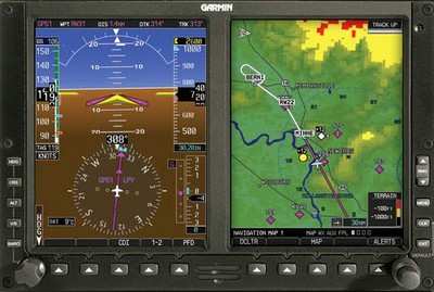
Garmin announces new features for the G500/G600 Flight Display Systems!
Garmin has unveiled new features and equipment compatibility for the G600 and G500 flight display system’s. With the latest software and the new GAD 43e adapter, the G600 and G500 can display and control altitude preselect and vertical speed as well as display DME (distance measuring equipment) distance, analog radar altitude, analog nav data and more.
Garmin’s vice president said “by integrating this data, aircraft owners have an opportunity to clean up their panel and enhance the reliability of the instruments by removing older equipment”.
 Just like the GAD 43, the GAD 43e allows Garmin’s digital Attitude and Heading Reference System (AHRS) to provide analog attitude information for use with select third-party autopilot systems in place of a costly-to-maintain attitude indicator or remote vertical gyro (VG). Just like the GAD 43, the GAD 43e allows Garmin’s digital Attitude and Heading Reference System (AHRS) to provide analog attitude information for use with select third-party autopilot systems in place of a costly-to-maintain attitude indicator or remote vertical gyro (VG).
The GAD 43e enables the G600/G500 flight display system to display marker beacon lamps, DME indications, ADF pointers, and analog radar altimeter read out, allowing the pilot to clean up the panel. It also allows aircraft owners to interface their existing compatible analog NAV radios and display VOR/LOC/GS with the G600/G500 flight display system.
|
![]()
![]()