The New Garmin Aera 796/795!
 This product is amazing! Garmin is now introducing the new aera 796 and aera 795, a new portable aviation navigation device. As Garmin’s new product, the aera 796 has the popular features of the GPSMAP696, and then added new capabilities such as touchscreen user interface, pilot-selectable screen orientation and 3D vision!
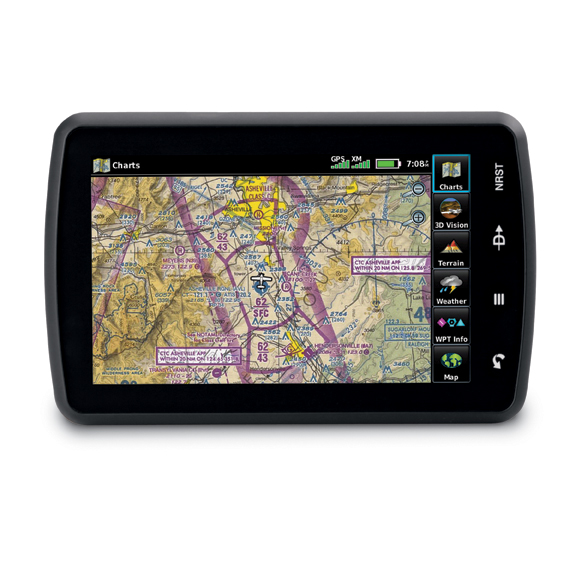
This aera 796 also takes the pilot a step closer to a paperless cockpit offering a digital document viewer, scratch pad and pre-loaded geo-referenced AeroNav IFR and VFR enroute charts.
Â
 The aera 796 has a high-resolution and sunlight readable 7 inch capacitive touchscreen display that can be viewed in portrait or landscape mode. This design is optimized to fit on the yoke and perfectly sized as a knee-mounted device. There are four touch keys on the the unit representing “back”, ‘menu”, “direct-to” and “nearest” for quick navigation to frequently used functions, and because the aera 796 customizable, the user can also pick favorite features or pages to anchor as icons along the bottom of the screen for even faster access. With finger touchable icons, intuitive pictures and labels this is a must have.
Â
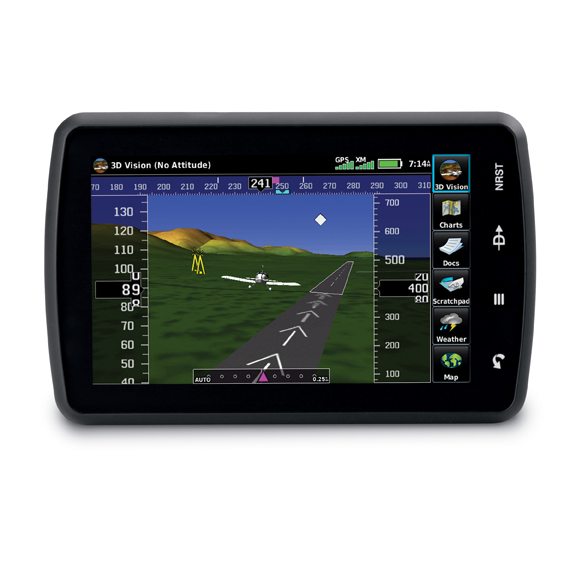
Enhanced situational awareness with 3D Vision
The aera 796 features 3D Vision which is a unique 3D view of database-generated terrain. 3D Vision uses GPS position and the terrain-alerting database to recreate a behind the aircraft perspective view of the topographic landscape. The resulting virtual reality display offers pilots a supplemental 3D depiction of land and water features including terrain, obstacles, runways and airport signposts all shown in relative proximity to the aircraft. With the flick of your finger, the 3D view can be rotated around the aircraft to easily view the surround terrain.Â
Â
The path to a paperless cockpit
The IFR enroute charts and VFR Sectional charts come pre-loaded, and the aera 796 also includes geo-referenced Garmin FliteCharts. With FliteCharts, pilots can quickly find and view all departure procedures, standard terminal arrival routes, approach charts and airport diagrams, with a ChartView enablement option. Other new features include a built in digital document viewer that enables the pilot to load and view PDF documents, JPEG photos, and many other electronically materials including checklists and detailed performance/procedural data from the aircraft flight manual. There is also a convenient scratch pad for writing down clearances or other important notes (don’t forget to pick up milk list!).
Â
Added support for helicopter missions
The addition of option city Navigator data on the aera 796 allows the user to stear and locate any desired surface address for use as flight play waypoint or for aerial direct-to navigation. This makes it even easier for helicopter and fixed-wing operators to respond to critical missions around streets and highways, survey land or perform search and rescue operations.
Â
Instrument back up, weather and traffic
Garmin’s patented Panel Page on the aera 796 offers a back up solution to the flight instrument panel with its exclusive display of GPS derived panel information, with track indication, GPS altitude, groundspeed, vertical speed and turn indication. The internal GPS provides position updates 5x per second. Also includes GXM 40 receiver for XM WX Satellite Weather and SiriusXM Radio. XM WX Satellite Weather gives next generation radar, aviation routine weather reports, terminal aerodrome forecasts, temporary flight restrictions, lightning, winds aloft, turbulence forecasts, PIREPs, icing forecast and other important weather products. The aera 796 will also display traffic if coupled to a compatible traffic source like the GTX 330, showing TIS where available. 
Safetaxi, Airport Directory and more….
Taxiing at unfamiliar airports is made easier thanks to SafeTaxi®, which includes geo-referenced diagrams of over 1,000 U.S. airports that identify runways, taxiways and hangars, as well as the aircraft’s exact location on the field. The aera 796 also has AOPA Airport Directory data, an electronic version of AOPA’s popular U.S. pilot guide, which includes information for over 5,300 public -use airports and nearly 7,000 FBOs. Optionally, pilots can purchase the AC-U-KWIK airport directory database, which features worldwide airport information for more than 7,800 airports globally, and contains hard-to-find information for pre-flight planning in North America, Europe, Asia, Central America, the Caribbean, South America, Africa and Australia.
North, Central and South American customer that do not require XM WX Satellite Weather and SiriusXM Radio may interested in the aera 795 Americas that has identical features to the aera 796 except that is it not XM capable.
Databases Bundles
Managing databases is easier than ever with database Bundles, annual subscriptions for multiple databases, all for a single, low price. Available through fly.garmin.com

 Want it? Gotta have it?
Being the number one Garmin dealer in Canada you need to come see us and order it today! This product speaks for itself. With the capabilities that it offers, availability, the look, the accessories and right down the packaging, this is a must have for every pilot! Call us and we will have our demo in shortly!
Â
Maxcraft Avionics is a leader in airplane and helicopter avionic system upgrades like the Garmin GTN series, including installation of everything from a basic VHF Radio and simple Garmin portable GPS all the way to TCAS, EFIS, and autopilot systems. We have the largest avionics facility in Canada and we have over 20,000 unique part numbers in our in inventory to repair your aircraft or upgrade your cockpit.
Â


